04 Oct Using Safetipin Nite to Collect Safety Data in Cities
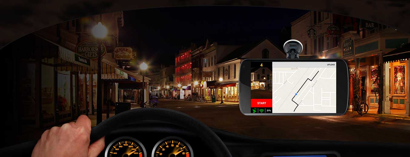
Safetipin has launched a new app earlier this year called Safetipin Nite. This app has been specifically designed to take photographs of the city at night in order to supplement the data that is collected on Safetipin through crowdsourcing. The Safetipin app works as a tool for citizens to audit and rate public spaces on defined parameters of safety. Safety here is defined in relation to fear and crime, specifically on violence against women. While the Safetipin app can be downloaded by individuals to input and see all the available data, the Safetipin Nite is a tool to collect data through photographs. The phone is attached on to the windscreen of a car and takes photographs at regular intervals as the car moves along.
As the data is collected, it is directly uploaded and it is used to code on the basis of the 8 parameters of the Safetipin app – lighting, openness, visibility, crowd, presence of women, presence of security, availability of public transport and the state of the walk path. Once the data is coded, it appears as an audit pin on the Safetipin app and web interface. Therefore the data collected through the photographs can be seen by people in the city to make safer decisions.

The purpose of developing this app was to find a way to collectlarge scale data in cities at regular intervals for use by urban planners and other urban stakeholders. We have begun using this method
to collect data in five cities – Delhi NCR, Mumbai and Bengaluru in India; Nairobi in Kenya and Bogota in Colombia. We will soon be starting data collection in another ten cities in the next few months.
This data is very useful for planners, police and others as it gives safety parameters over a large part of the city. For example in Delhi, data has been collected over 4000 km of a road across the entire city and similarly over 3000 km in Bogota city. This means that it can be used for urban decision making and resource planning by city officials. For example in Delhi, the data has been shared with the Public Works Department (PWD), Delhi Police and the MCD for them to use in assessing the level of lighting in the city, the state of the walking path or how safe people feel in the city. Thus, if PWD or MCD wants to take a decision on which parts of the city need to be improved lighting, then the Safetipin data can be used to gauge where the lighting scores are low.
Further, it is useful as it allows regular data collection. Thus, if the city government effects changes which could have an impact on safety, we can redo the audits in that area and show that in fact the safety of the area has improved because of specific initiatives or programs. It, therefore, becomes a very useful tool to measure change and impact.
We work with cab companies in the collection of data and have forged a global partnership with Uber who is supporting this initiative in expanding it to cities both in India and globally.